Varves of the Month for 8/1/2011 - 9/30/2011
Varves of West Canada Creek Valley, western Mohawk Valley
This month's image is five spliced high resolution images that show ice-proximal varves in a core collected at Poland in the West Canada Creek valley, western Mohawk Valley region of central New York. The varves were collected during a Tufts University GEO 115: Glacial and Quaternary Geology field trip in October, 2010. The core was split and partially dried (LINK: Lab Methods – Core preparation) to reveal differences between sediment layers. A stone found in the core along the plane in which the core was split was removed, washed, and reinserted in the core.

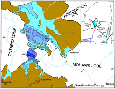
Glacial Lake Cedarville in the western Mohawk Valley of New York that formed during the recession of the last ice sheet about 17,000 yr ago. Shown is the maximum extent of a Mohawk Lobe readvance (Salisbury Readvance). At the same time the Ontario Lobe is advancing from the west and will continue to advance as the Mohawk Lobe recedes. Water was impounded in the valley between the Mohawk and Ontario Lobes and filled the basin to the level of the divide between the Mohawk and Susquehanna drainage basins. The spillway that controlled the level of Lake Cedarville was at Cedarville, 300 meters above the floor of the Mohawk Valley. Water spilled into the Unadilla River which drains into the Susquehanna River further south. Areas beneath water today have deposits of varved silt and clay with iceberg dropstones and sediment pellets. Water depth in the lake is indicated with bathymetric contours in meters. Initials on the diagram are towns: R = Rome, H = Herkimer and Hinckley (to north), LF = Little Falls, SJ = St. Johnsville, P = Poland, N = Newport, and M = Middleville. The blue dashed lines represent the course of modern streams. Click to download a high resolution version of this map (~1 MB JPG).
The varves were deposited in glacial Lake Cedarville during a readvance of the Mohawk Lobe (from the east) at about 17,000 years ago (see paleogeographic reconstruction below). Varve thickness was controlled by glacial meltwater activity as meltwater moved to the west away from the Mohawk Lobe. Varves in this part of the sequence are dark gray as a result of an eastern source where ice flowed over gray and black shale. Clay beds deposited by meltwater from the Mohawk Lobe tend to have a bluish green color.
The summer or melt season layers of each varve (light-colored units) are composed of a stack of micrograded units of fine sand and silt. Grain size varies within the summer layer with the coarser units (fine sand) having a very light gray color. Summer and winter layer thicknesses in this sequence are not well correlated.

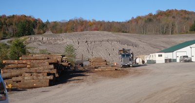
Distant view of varve exposure.

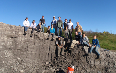
GEO 115 class on outcrop of varves at Poland.
Past Varves of the Month...
- 6/1/2008 - Connecticut Valley Varves at Canoe Brook, Dummerston, Vermont
- 4/27/2008 - Connecticut Valley Varves from Kelsey Ferguson Brickyard, Redland Brick Co., East Windsor, Connecticut.
- 7/1/2008 - Champlain Valley varves at Keesville, NY
- 8/1/2008 - Connecticut Valley Varves at Aldrich Brook, Westmoreland, New Hampshire
- 9/1/2008 - Connecticut Valley Varves, Perry Hill Basin (PHS), Charlestown, New Hampshire
- 10/1/2008 - Connecticut Valley Varves, Perry Hill Basin (PHN), Charlestown, New Hampshire.
- 11/1/2008 - Connecticut Valley Varves, Aldrich Brook site, Westmoreland, New Hampshire
- 12/1/2008 - Connecticut Valley Varves, Aldrich Brook site, Westmoreland, New Hampshire
- 1/1/2009 - Mine fire reclamation site, Olyphant, Pennsylvania
- 2/1/2009 - Connecticut Valley Varves, Perry Hill Basin (PHS), Charlestown, New Hampshire
- 3/1/2009 - Connecticut Valley Varves, Perry Hill Basin, Charlestown, New Hampshire
- 4/1/2009 - Connecticut Valley Varves, Perry Hill Basin, Charlestown, New Hampshire.
- 5/1/2009 - Connecticut Valley Varves, Perry Hill Basin, Charlestown, New Hampshire
- 6/1/2009 - Connecticut Valley Varves, Perry Hill Basin, Charlestown, New Hampshire
- 7/1/2009 - Connecticut Valley Varves, Perry Hill Basin, Charlestown, New Hampshire
- 8/1/2009 - Connecticut Valley Varves, Perry Hill Basin, Charlestown, New Hampshire
- 9/1/2009 - Connecticut Valley Varves, Perry Hill Basin, Charlestown, New Hampshire
- 10/1/2009 - Connecticut Valley Varves, Perry Hill Basin, Charlestown, New Hampshire
- 11/1/2009 - Connecticut Valley Varves, Perry Hill Basin, Charlestown, New Hampshire.
- 12/1/2009 - Connecticut Valley Varves, Perry Hill Basin, Charlestown, New Hampshire
- 1/1/2010 - Connecticut Valley Varves, Perry Hill Basin, Charlestown, New Hampshire
- 2/1/2010 - Varves along Starrucca Creek near Lanesboro, Pennsylvania
- 3/1/2010 - Varves in the Don Valley, Toronto
- 4/1/2010 - Varves along Sandy Stream, Dennistown Plantation near Jackman, Maine
- 5/3/2010 - Varves from Glacial Lake Great Falls in Montana
- 6/4/2010 - Varves from Charlestown, NH
- 7/1/2010 - Varves from Redlands Brick Co. (Kelsey Ferguson Brickyard, South Windsor, Connecticut) - A varve that Antevs missed
- 8/1/2010 - Varves from Glastonbury, Connecticut
- 9/1/2010 - Varves from North Hatfield, Massachusetts
- 10/1/2010 - Varves from Newbury, Vermont
- 11/1/2010 - Varves from Newbury, Vermont
- 12/1/2010 - Varves from Newbury, Vermont
- 2/1/2011 - Connecticut Valley Varves at North Hatfield, Massachusetts
- 3/1/2011 - Connecticut Valley Varves Kelsey Ferguson (Redlands Brick Co.), South Windsor, Connecticut
- 6/1/2011 - Connecticut Valley Varves: Core at Scantic, East Windsor, Connecticut
- 10/1/2011 - Varves of West Canada Creek Valley, western Mohawk Valley collected in Newport, NY
- 12/1/2011 - Connecticut Valley Varves at Claremont Junction, NH
- 3/1/2012 - Connecticut Valley Varves at Westmoreland, NH
- 7/1/2012 - Connecticut Valley Varves at Rt. 12A drill site in North Charlestown, N.H.


