Northeastern U.S. and Adjacent Canada Varve Sequence Downloads
Varve sequences and individual outcrop or bore hole measurements from the northeastern U.S. and adjacent Canada that were not a part of the original New England Varve Chronology (NEVC, lower and upper Connecticut varves) of Antevs or the North American Varve Chronology (NAVC) are available here for download. These records include some long sequences and some sequences correlated by Antevs (1928) over long distances but not connected to the NEVC or NAVC. There are also more recent individual outcrop records that either have been matched to the NEVC and NAVC or are unconnected records. For links to the original NEVC varve sequences of Antevs (1922, 1928) go to the NEVC Normal Curves Download page. For the NAVC varve records go to NAVC Normal Curves Downloads [link] page. For a translation of NEVC (NE) varve year numbers to the new NAVC (AM) varve year numbers or vice versa go to the NEVC/NAVC Conversion page.
Individual varve sequences can be downloaded: 1) from the varve file menu or 2) from a map showing their geographic location (area from which varve sections were measured to produce the varve sequence). You also have the option of downloading a folder with all of the files. The downloadable data files are all in ASCII text files. Some files have just varve year and total couplet thickness while others may have varve year and summer bed, winter bed, and total couplet thickness. Headers in the data files explain their content.
- Download by Filename
- Choose from Map
- Choose from Timeline
All files are ASCII text files assembled with separate columns for varve year and either 1) annual couplet thickness in centimeters, or 2) summer layer, winter layer, and total annual couplet thickness in centimeters. All varve year numbers run from low number (older) to high number (younger). When a file or group of files is described as �not connected� this means that the files have not been correlated or matched to either the NEVC or NAVC and the records will have their own individual numbering system. Right-click on any of the links in blue below and choose "save file as..." or �save link as..." to download the desired file. Those links that are named XXXXfolder are .zip archives which contain the associated text files. You must uncompress these files using 7zip (free), winzip (fee) or the integrated Windows or Mac decompression utilities.
NOTE: All NAVC files will have a file name ending in "AM".
Download ALL Northeastern U.S. Data (~5.8 MB .zip archive)
All items below are links to individual Notheastern U.S. varve data files or folders.
New Jersey (Not connected to NEVC or NAVC)
- NJ101.TXT Varves 1-200, Little Falls, NJ, site #101 plot from Antevs (1928).
- NJREEDS.TXT Varves -1097 to 1434 from Lake Hackensack plots of Reeds (1926), Little Ferry, NJ.
- HACK1-5.TXT Varves 1-952, Lake Hackensack, northeastern NJ, HACKENSACK 1-5 plots of Antevs (1928). Note: same varves as Reeds (1926) but different numbering system with more varves than counted by Reeds in same sequence. Intervals that match Reeds are: A20 to 333 = R-1063 to -750, A560 to 694 = R-641 to -507, A780-852 = R-405 to -333.
- HACK6-8.TXT Varves 1101-1490, Lake Hackensack, northeastern N.J., HACKENSACK 6-8 plots of Antevs (1928). Note: same varves as Reeds (1926) but different numbering system with more varves than counted by Reeds in same sequence. Intervals that match Reeds are: A1101 to 1120 = R1 to 20, A1290 to1400 = R230 to 340. Most of sequence is non-glacial.
Sequence on Long Island, NY (Not connected to NEVC or NAVC)
- NY122.TXT Varves 1-71, Glen Head, north shore of Long Island from Antevs (1928).
Sequences in Rhode Island (Not connected to NEVC or NAVC)
- RI141.TXT Varves 1-102, in Antevs’ (1928) section 141 south of Providence in bluff on west side of Narragansett Bay near Gaspee Point.
- RI142.TXT Varves 1-157, in Antevs’ (1928) section 142 south of Providence and east of Narragansett Bay in clay pit near Barrington.
- RI143.TXT Varves 1-54, in Antevs’ (1928) section 143 in providence near Seekonk River along railroad. Section rests on bouldery substrate, probably till.
Sequences in eastern Massachusetts (Not connected to NEVC or NAVC)
- MA144.TXTVarves 1-41 in Antevs’ (1928) section 144 in brickyard at Taunton.
- MA145.TXTVarves 1-89 in Antevs’ (1928) section 145 in brickyard at Middleboro.
- MA146.TXT Varves 1-165 in Antevs’ (1928) section 146 in brickyard at Bridgewater.
- MA147.TXTVarves 1-19 in Antevs’ (1928) section 147 in brickyard north of Bridgewater.
Hudson Valley, Haverstraw, NY/Quinnipiac Valley, New Haven, CT correlated sequences (Not connected to NEVC or NAVC)
- HUDA0-7.TXT Varves 1-700, Hudson Valley, Haverstraw, N.Y., NEW HAVEN A1-A4 plots of Antevs (1928).
- HUDB1-6.TXT Varves 101-577, Hudson Valley, Haverstraw, N.Y., NEW HAVEN B1-B3 plots of Antevs (1928).
- CONNH2-6.TXT Varves 201-544, Quinnipiac Valley, New Haven, Conn., NEW HAVEN C2-C3 plots of Antevs (1928).
Middletown to New Britain, CT area (Not connected to NEVC or NAVC)
- CTBerlin folder Varves in 3 measured sections near Berlin, Conn. correlated to each other. Till near base of some sections. All sections overlain by what Antevs’ interprets as clayey till. Included are the following records:
- CTBerlB.TXT – Varves 1-33, bottom plot of Antevs (1928) Berlin sequence
- CTBerlT.TXT – Varves 1-37, top plot of Antevs (1928) Berlin sequence
- CTBr136.TXT – Varves 1-16, plot of Antevs’ (1928) section 136 near Berlin, Antevs’ correlation to other Berlin records not as clear as correlation of other two.
- CTNwfld.TXT Varves 1-39 constructed by Antevs (1928) from three sections at Newfield, Conn. north of Middletown. One section interpreted by Antevs to be overlain by clayey and stony till.
- CT132.TXT Varves 1-32 of section 132 of Antevs (1928) NW of Newfield, Conn. Not connected to any other section. Sequence overlies till and is overlain by package of “compressed” and deformed varves and till.
- CT137.TXT Varves 1-33 with a gap in section 137 of Antevs (1928) in New Britain, Conn. Antevs refers to this as the New Britain sequence. Not connected to any other sequence.
- CT138.TXT Varves 1-12 in section 138 of Antevs (1928) in Connecticut Valley north of Middletown. Section rests on till and is overlain by till composed of deformed varves.
Lower Connecticut Valley (matched to NEVC and NAVC)
- PET1-2mergNE.TXT, Varves NE 2853-4116 (as adjusted to original NEVC of Antevs, 1922, 1928)
- PET1-2mergAM.TXT, Varves AM 2853-4129, Composite of two side-by-side drill cores collected and measured in 2009 by Laura Carter, Jeremy Wei, Chris Smith, and Jack Ridge at Petersen Farm in South Windsor, Connecticut.
- GL1-2mergNE.TXT, Varves NE 2868-4771 (as adjusted to original NEVC of Antevs, 1922, 1928)
- GL1-2mergAM.TXT, Varves AM 2868-4785, Composite of two side-by-side drill cores collected and measured in 2009 by Laura Carter, Jeremy Wei, Chris Smith, and Jack Ridge in Glastonbury, Connecticut.
- SC1-2mergNE.TXT, Varves NE 3020-4444 (as adjusted to original NEVC of Antevs, 1922, 1928)
- SC1-2mergAM.TXT, Varves AM 3020-4457, Composite of two side-by-side drill cores collected and measured in 2009 by Laura Carter, Jeremy Wei, Chris Smith, and Jack Ridge in Scantic, East Windsor, Connecticut.
- KF-ABCD09-NE.TXT, Varves NE 3293-4168.
- KF-ABCD09-AM.TXT, Varves AM 3297-4181.Connecticut Valley, Kelsey Ferguson Brickyard, Redland Brick Co., South Windsor, Conn. as published in Stone and others (2005) and expanded in 2009. NEVC and NAVC records measured by Jack Ridge, Laura Carter, Jeremy Wei, and Chris Smith from outcrop cores (summer, winter, and total couplet thickness). Five adjacent outcrop transects of identical thicknesses were fused to form the varve record.
- CHIC1b.TXT Varves NE 3586-3639
- CHIC1b-AM.TXT, Varves AM 3596-3651, Along Center Street in Chicopee, Massachusetts on east side of Connecticut River. Sequences rests on till composed of reworked lake beds, probably from Chicopee readvance, and grades upward into deltaic sand. NEVC and NAVC records measured by Jack Ridge and Charles Pace at outcrop.
- SHD1-2mergNE.TXT, Varves NE 3996-5137 (as adjusted to original NEVC of Antevs, 1922, 1928)
- SHD1-2mergAM.TXT, Varves AM 4009-5151, Composite of two side-by-side drill cores collected and measured in 2009 by Laura Carter, Jeremy Wei, Chris Smith, and Jack Ridge in South Hadley, Massachusetts.
- UMASS.TXT , Varves NE 4638-6027
- UMASS-AM.TXT, Varves AM 4651-6042, From long cores, Connecticut Valley, Amherst, Massachusetts on Univ. of Massachusetts campus as reported in Rittenour (1999). Original NEVC measurements with notes on errors, core conditions, and gaps between core drives and for contorted layers. NAVC version is corrected.
- NHT1-2mergNE.TXT, Varves NE 4652-6064 (as adjusted to original NEVC of Antevs, 1922, 1928)
- NHT1-2mergAM.TXT, Varves AM 4665-6079 Composite of two side-by-side drill cores collected and measured in 2009 by Laura Carter, Jeremy Wei, Chris Smith, and Jack Ridge in North Hatfield, Massachusetts.
- MASSRR folder NEVC and NAVC varve records at the River Road section, South Deerfield, Massachusetts by George Thomas (1984) and Laura Levy (1998). Data files include:
- RRThom84.TXT � Varves NE 5103-5238. Digitized from graph in Thomas (1984).
- RRThomas1984-AM.TXT Varves AM 5118-5254
- RRLevy98.TXT � Varves NE 5008-5201
- RRLevy98-AM.TXT Varves AM 5022-5217
- HINTOP.TXT Varves NE 5533-5587
- HINTOP-AM.TXT, Varves AM 5552-5606, NEVC and NAVC varve records from Connecticut Valley, Hinsdale, NH, measured at outcrop by Jack Ridge, Sarah Brown, and Jake Woland.
- CANOEBK folder NEVC and NAVC varve records from the Canoe Brook section in Dummerston, VT from Ridge and Larsen (1990) with later added couplets at base of section. Measured at outcrop by Jack Ridge and Fred Larsen. Data files include:
- CANOEBK.TXT Varves NE 5685-6234
- CANOEBK-AM.TXT Varves AM 5699-6249
- CanBk5yr.TXT � 5-yr running average of CANOEBK.TXT described above.
- CanBk5yr-AM.TXT � 5-yr running average of CANOEBK-AM.TXT described above.
- MILLBK.TXT Varves NE 5752-6024
- MILLBK-AM.TXT, Varves AM 5767-6039, NEVC and NAVC varve records from Mill Brook, Connecticut Valley, Putney, VT. Measured at outcrop by Jack Ridge.
- ALDmergNE.TXT, Varves NE 6043-6454, (uses Lower Conn. Varves numbers system)
- ALDmergAM.TXT, Varves AM 6058-6469, Composite of two side-by-side drill cores collected and measured in 2007 by Catherine Beck and Jack Ridge south of Aldrich Brook in Westmoreland, NH. This section extended Antevs� Lower Connecticut Varves and created an overlap with the Upper Connecticut Varves.
- VTBFalls folder Folder with Varve records and location maps of sections (PDFs) north of Bellows Falls, VT. and the Williams River Valley along the west side of the Connecticut River on Commissary and Little Commissary Brooks, and an unnamed brook all south of Hogan Hill. Included are the following NEVC and NAVC records:
- 591bfw.TXT - NE 6094-6158 on Little Commissary Brook
- 591bfw-AM.TXT - AM 6109-6173 on Little Commissary Brook
- 592bfw.TXT - NE 6075-6157 on Little Commissary Brook
- 592bfw-AM.TXT - AM 6090-6172 on Little Commissary Brook
- 593bfw.TXT - NE 6138-6188 on Little Commissary Brook
- 593bfw-AM.TXT - AM 6153-6203 on Little Commissary Brook
- 597bfw.TXT - NE 6221-6259 on Commissary Brook
- 597bfw-AM.TXT - AM 6236-6274 on Commissary Brook
- 600bfw.TXT - NE 6099-6127 on unnamed brook
- 600bfw-AM.TXT - AM 6114-6142 on unnamed brook
- 601bfw.TXT - NE 6095-6109, 6115-6148, and 6158-6183 (2 bluffs) on unnamed brook
- 601bfw-AM.TXT - AM 6110-6124, 6130-6163, and 6173-6198 (2 bluffs) on unnamed brook
- 602bfw.TXT - NE 5974-5994 on unnamed brook
- 602bfw-AM.TXT - AM 5989-6009 on unnamed brook
- 639bfw.TXT - NE 6077-6235 on Commissary Brook
- 639bfw-AM.TXT - AM 6092-6250 on Commissary Brook
- CHN1-2mergNE.TXT, Varves NE 6159-6202
- CHN1-2mergAM.TXT, Varves AM 6174-6217, Composite of two side-by-side drill cores collected and measured in 2008 by Jack Ridge in north end of town of Charlestown, NH. This section contains very thick ice-proximal varves.
- CHS1-2mergNE.TXT, Varves NE 6164-6219
- CHS1-2mergAM.TXT, Varves AM 6179-6234, Composite of two side-by-side drill cores collected and measured in 2008 by Jack Ridge in south end of town of Charlestown, NH. This section contains very thick ice-proximal varves.
Merrimack Valley (matched to NEVC and NAVC)
- MER1.TXT Varves NE 5959-6200
- MER1-AM.TXT, Varves AM 5974-6215, NEVC and NAVC records from bank of Merrimack River, Garvins Falls Rd. north of Soucook River, Concord, N.H. Measured at outcrop by Sharon Zaboly Kelley and Jack Ridge as reported in Ridge and others (2001).
- MER2.TXT Varves NE 5924-6243
- MER2-AM.TXT, Varves AM 5939-6258, Varve records from Hayward Brook, Penacook, N.H. Measured at outcrop by Meredith Kelly and Jack Ridge as reported in Ridge and others (2001).
- MER3.TXT Varves NE 6050-6194
- MER3-AM.TXT, Varves AM 6065-6209, Bryant Brook, Canterbury, N.H. Measured at outcrop by Meredith Kelly, Rich Pendleton, and Jack Ridge as reported in Ridge and others (2001).
Upper Connecticut and Passumpsic Valleys (correlated to NEVC)
- 12A1-2mergNE.TXT, Varves NE 7014-7107 (as matched to original NEVC of Antevs, 1922)
- 12A1-2mergAM.TXT, Varves AM 6696-6789, Composite of two side-by-side drill cores collected and measured in 2008 by Jack Ridge, Rob Bayless, and Jody Dean along west side of Rt. 12A in North Charlestown, NH.
- 282SPW-NE.TXT, NE 7008-7053 (as matched to original NEVC of Antevs, 1922)
- 282SPW-AM.TXT, AM 6690-6735, Outcrop measurement by Jack Ridge in 2002 along bank of Connecticut River in North Charlestown, NH.
- PHSmergNE.TXT, NE 6569-7033 (as adjusted to match original Upper Connecticut Varves of NEVC of Antevs, 1922).
- PHSmergAM.TXT, AM 6252-6789, Composite of southern Perry Hill site (along Ox Brook) where two side-by-side drill cores were measured in 2007 by Emily Voytek and Jack Ridge in Perry Hill Basin, Charlestown, NH.
- PHNmergNE.TXT, NE 6570-7006 (as adjusted to match original Upper Connecticut Varves of NEVC of Antevs, 1922).
- PHNmergAM.TXT, AM 6252-6769, Composite of northern Perry Hill site where two side-by-side drill cores were measured in 2007 by Emily Voytek and Jack Ridge in Perry Hill Basin, Charlestown, NH.
- WB12mergNE.TXT, Varves NE 6600-6801 as adjusted to match original NEVC of Antevs (1922)
- WB12mergAM.TXT, Varves AM 6283-6484, Composite of two side-by-side drill cores collected and measured in 2008 by Jack Ridge, Rob Bayless, and Jody Dean in Wethersfield Bow, VT.
- CLJmrg12NE.TXT, Varves NE 6600-7079 as adjusted to match original NEVC of Antevs (1922)
- CLJmrg12AM.TXT, Varves AM 6283-6761, Composite of two side-by-side drill cores collected and measured in 2008 by Jack Ridge, Rob Bayless, and Jody Dean Along west side of Rt. 12A in North Charlestown, NH.
- NEWBURY folder Folder with data files from Newbury, VT, Connecticut Valley site #73 of Antevs (1922), fully measured in outcrop cores as reported in Ridge and Toll (1999). Cumulative uncertainty above NE 7510 at 8676 (AM 7192-8358) is +35/-20. (summer, winter, and total couplet thickness)
- NEWBswT.TXT, Varves NE 6944-8676, Newbury, VT.
- NEWBswT-AM.TXT, Varves AM 6627-8358, Newbury, VT.
- NEWB5yr.TXT, 5-yr running average of total varve thickness for the Newbury, VT. section (NE version NEWBswT.TXT listed above).
- NEWB5yr-AM.TXT, 5-yr running average of total varve thickness for the Newbury, VT. section (AM version NEWBswT-AM.TXT listed above).
- LOUG.TXT Varves NE 7036-7087
- LOUG1935-AM.TXT, Varves AM 6718-6769, Comerford Dam, Vt., Connecticut Valley, NEVC and NAVC measurement of Lougee (1935).
- ComDam.TXT, Varves NE 7036-7154
- ComDam-AM.TXT, Varves AM 6718-6836, NEVC and NAVC versions near Lougee�s Comerford Dam site in Vermont, average of three transect measurements by Marc Brochu and Jack Ridge as published in Ridge and others (1996).
- VTEBarn folder Folder with NEVC and NAVC sequences measured in gully 1 km west of Comerford Dam in East Barnet, VT. by Sarah Brown and Jack Ridge as published in Ridge and others (1996):
- BAR1.TXT NE 7215-7350
- BAR1-AM.TXT AM 6897-7032
- BAR2.TXT NE 7241-7294
- BAR2-AM.TXT AM 6923-6976
- PAS1.TXT Varves NE 7039-7176
- PAS1-AM.TXT Varves AM 6721-6858 Passumpsic Valley, East Barnet, VT., Inwood area of Antevs (1922). NEVC and NAVC measured at outcrop by Mark Brochu and Jack Ridge as published in Ridge and others (1996).
- PAS2.TXT, Varves NE 7051-7785 with some minor gaps
- PAS2-AM.TXT, Varves AM 6733-7467 with some minor gaps, Passumpsic Valley, East Barnet, VT. NEVC and NAVC versions of measurement of outcrop cores by Brant Wilson (2000). (summer, winter, and total couplet thickness)
- VTWellsR folder Folder contains 5 outcrop records from the Wells River Valley near Wells River, VT. These records form four sequences (A-oldest to D-youngest) with some gaps that span approximately 520 years. Only crude matches have been found between the sequences and the upper Connecticut varves of the NEVC or NAVC. Deposition in the Wells River Valley was in a tributary embayment of the glacial lake in the Connecticut Valley and the Wells River Valley became an environment where deposition was dominated by meteoric input to the lake with no or very minor glacial runoff. Summer layers in the Wells River Valley are beds deposited by summer runoff events and winter layers are frequently interrupted by sand partings and layers that probably represent late summer precipitation events in an environment where clay deposition begins in the late summer. As a result, annual layers are difficult to interpret and these records are very difficult to measure accurately. Thus, it is very difficult to confidently match the records to the NEVC or NAVC, which are formulated from records of glacial varves dominated by glacial runoff deposition. The approximate time of deglaciation in this area, very crude intermittent matches with the NEVC and NAVC in places, overall trends in varve thickness, and some key event horizons (especially NE7500 or AM7182 associated with a prominent change in varve lithology) suggest the following tentative correlations:
- Sequence A (201-450) in WR1AswT.TXT and WR2AswT.TXT = NE 7090-7340 or AM 6772-7022
- 1-yr gap between sequences A and B
- Sequence B (1-23) in WR1BswT.TXT = NE 7342-7364 or AM 7024-7046
- 2-yr gap between sequences B and C
- Sequence C (1-90) in WR1CswT.TXT = NE 7367-7456 or AM 7049-7138
- 20-yr gap between sequences C and D
- Sequence D (1-133) in WR1DswT.TXT = NE 7475-7607 or AM 7157-7289
Lamoille and Winooski Valleys, VT
- ESSEX folder Folder with varve sequences of Lamoille and Winooski Valleys near Burlington, Essex Junction, and Cambridge, VT. Sequences are bounded above by marine sediment and upper-most varves may be in part marine. Not correlated to NEVC and NAVC. Sequences include:
- ESSEXA.TXT Varves 1-345, Winooski and Lamoille Valleys, near Burlington in Essex Junction area, ESSEX A1-A2 VT plots of Antevs (1928).
- ESSEXB.TXT Varves 55-153, 158-284 Winooski Valley, near Burlington in Essex Junction area, ESSEX B1-B2 VT plots of Antevs (1928).
- ESSEXC.TXT Varves 78-305, Lamoille Valley, Cambridge, Vt., ESSEX C1-C2 VT plots of Antevs (1928).
- VTMUZY.TXT Varves NE 6979-7254 (intermittent match)
- VTMUZY-AM.TXT Varves AM 6661-6936 (intermittent match) Muzy Road section in Dog River valley, 6 km SW of Montpelier (Larsen and others, 2001). Measured at outcrop by Fred Larsen. Correlated by Jack Ridge to NEVC and NAVC.
- VTWRVL.TXT Varves NE 7024-7204 (intermittent match)
- VTWRVL-AM.TXT Varves AM 6706-6886 (intermittent match) Wrightsville Dam section in North Branch of Winooski River 5 km north of Montpelier (Larsen and others, 2001). Measured at outcrop by Fred Larsen and Stephen Wright. Correlated by Jack Ridge to NEVC and NAVC.
Northern Vermont (not connected to NEVC)
- NorthVT folder Folder with small isolated sequences and outcrop records of Antevs (1928) from northern Vermont, which are not connected to the NEVC. Included are the following sequences and records:
- VTCol160.TXT – outcrop record (Antevs’ section 160, local years 1-175) from Malletts Brook, Colchester/Milton line.
- VTFrfx.TXT - record from Antevs’ sections 161-163 (local years 1-178) from Fairfax.
- VTCam167.TXT - record from Antevs’ section 167 (local years 1-26) from Cambridge.
- VTOrl175.TXT - record from Antevs’ section 175 (local years 1-104) from Orleans.
- VTOrl176.TXT - record from Antevs’ section 176 on Barton River (local years 1-27) between Orleans and Coventry. Sequences at Coventry connected to each other (local years 1-111)
- VTCovA.TXT - record from Antevs’ section 177 and 178 (1-111)
- VTCovB.TXT - record from Antevs’ section 179 (26-46) VTCovC.TXT - short auxiliary record from Antevs’ section 177 (25-31)
- VTNwpt.TXT - record from Antevs’ sections 180-181 on bluffs of Lake Memphremagog near Newport (local years 1-140)
Champlain Valley, New York
- NYKIP.TXT Varves 1-67 in bluff section at Keeseville Industrial Park on Ausable River, Keeseville, New York. Varve section rests on till. Measured in outcrop cores by Jack Ridge. Not connected to any other sequence.
- NYBEEK.TXT Varves 1-194 with gaps of uncertain duration, stream cut along Ray Brook in Beekmantown, New York. Varve sequence rests on till. Sequence may not be useful for regional correlation because of gaps and changes in varve thickness over small distances at outcrop. Measured from outcrop cores by Jack Ridge and Katie Matthews. Not connected to any other sequence.
Maine
- CORN.TXT Varves NE 6077-6117
- CORN-AM.TXT Varves AM 6092-6132 Cornish, Maine, Ossipee River Valley as reported in Ridge and others (2001), Measured at outcrop by Brandy Canwell and Jack Ridge
- SS1LR.TXT Varves 1-171, Sandy Stream, Jackman, Maine from Nichols (2004). Measured by Jonathan Nichols and Jack Ridge from outcrop cores. (summer, winter, and total couplet thickness)
Southern Quebec adjacent to Vermont (not connected to NEVC)
- SoQUEB folder Folder with small isolated sequences and outcrop records of Antevs (1928) and Parent and Occhietti (1999) from southern Quebec adjacent to Vermont, which are not connected to the NEVC. Included are the following sequences and records:
- QUE144.TXT - record from just north of US border at Antevs’ Canadian section 144 (local years 1-272) along Tomifobia River near Beebe.
- QUE145.TXT - record from just north of US border at Antevs’ section 145 (local years 1-60) on Tomifobia River near Beebe (not connected to 144). Sequences at Tomifobia on Tomifobia River (local years (1-51)
- QUE146.TXT - section 146 of Antevs’ (1-51)
- QUE147A.TXT - section 147 of Antevs’ (24-46)
- QUE147P.TXT - section 147 of Antevs’ (16 yr sequence below local yr 1)
- QUE148.TXT - small 15-yr section resting on till at Ascot NE of Sherbrooke, Antevs’ section 148.
- QUE149.TXT - record from Antevs’ section 149 (local years 1-55) 38 km NW of Sherbrooke near Richmond.
- QUEDanv.TXT - section on Riviere Landry near Danville (local years 1-103 of Parent and Occhietti, 1999).
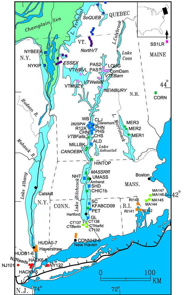
The map below has links that will take you to the text file download for the individual varve sequences outside of New England, according to the location or section of a valley where varves were measured to create the sequence.
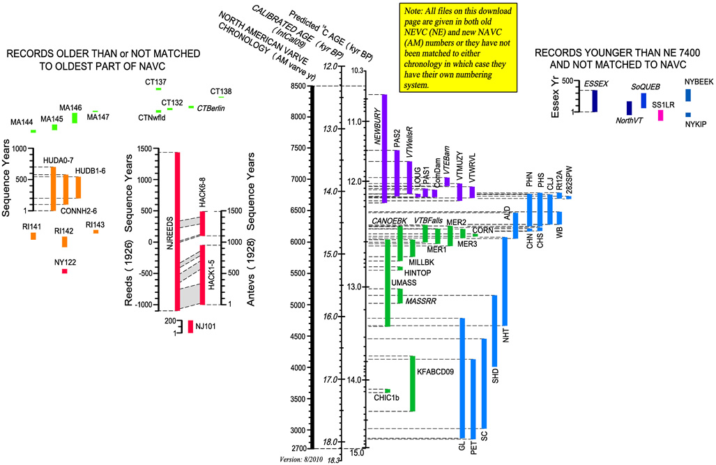
The timeline below has links that will take you to the downloads for the individual varve sequences outside of New England according to age. The plot shows how the different sequences of the NEVC overlap in time.