
Varve Project News
Charlestown and Westmoreland, NH Core Drilling (Summer 2007) |
8/19/2007 |
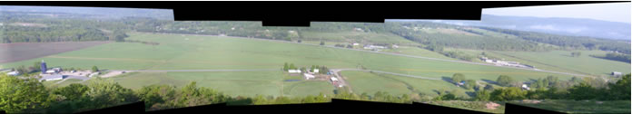
A panoramic view west of the southern drill site in Perry Hill basin (PHS) from the top of Perry Hill. The drill rig can be seen next to Ox Brook to the right of the farm in the center of the view. NH Rt 12 runs along the far side of the basin. The northern Perry Hill basin site is just concealed by trees at the right side of the image east of Rt 12. At the top center of the image is the flank of Calavant Mountain that separates the Perry Hill basin from the Connecticut River valley. The whole valley floor, except for the upper part of Calavant Mountain, was flooded by glacial Lake Hitchcock at the close of the last glaciation. During the summer of 2007, drilling occurred at 4 sites, two in the Perry Hill basin and one in the Clay Brook valley in Charlestown with an additional site further south near Aldrich Brook in Westmoreland. In May, collection of deep core samples began in the area between Charlestown and Claremont, NH. The drilling services of the USGS Water Science Center in Pembroke, NH were contracted for the project. The head driller was Glen Berwick who was assisted by USGS hydrogeologist Jim Degnan. |
Other News... |
|