Closure of the Claremont Gap
One of the main obstacles to creating a unified New England Varve Chronology (NEVC) in the Connecticut and Merrimack Valleys and obtaining an accurate calibration has been the Claremont Gap between the lower (LC) and upper (UC) Connecticut varve sequences. (for an explanation of the NEVC and Claremont Gap see History of Varve Chronology - North America) Over the past two decades crude matches between the two sequences (Ridge et al., 1996, 1999, 2001), time relations inferred from detailed surficial mapping in the Charlestown/Claremont area (Ridge, 2001), and new radiocarbon ages (Ridge, 2003, 2004) have been used to bridge the Claremont Gap or estimate its duration. All of these attempts failed to provide the definitive age relationship of the LC and UC sequences.
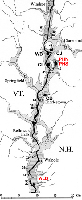
Location of the Aldrich Brook (ALD) and Perry Hill Basin (PHN and PHS) core sites in the Connecticut Valley of southern New Hampshire and Vermont. Numbered sections are varve sites of Antevs (1922) and abbreviated sites are core sites of the Jumbo Varve Project.
For the first time in 2008 the Claremont Gap has been closed with the definitive matching of varve sequences. A new varve record was measured that extends the LC varves (177 years in the Connecticut Valley to LC 6454) and ties them to new sequences matched to the UC sequence. The new core sites (Aldrich Brook in Westmoreland, NH and Perry Hill Basin, Charlestown, NH) are shown on the location map below, which shows an area of the Connecticut Valley of southern New Hampshire and Vermont. The Aldrich Brook (ALD) cores (two parallel cores taken 6 m apart and vertically offset by 0.6 m) were measured and analyzed by Catherine Beck (Beck, 2008) as part of her senior thesis work at Tufts University. The Perry Hill Basin North cores (PHN) were measured and analyzed by Emily Voytek (Voytek, 2008) as a part of her senior thesis work at Tufts University. The Perry Hill Basin South cores (PHS) were measured by Jack Ridge. Each PH site has two parallel cores taken 6 m apart and vertically offset by 0.6 m. Overlap of the PHN and PHS cores was used to fill gaps in the individual core records and develop a unified numbering system for this basin beginning with varve 1 as the oldest varve at PHS.
Shown on the first two sets of plots below are the overlapping varve sections that fill the Claremont Gap beginning with the match of the Aldrich Brook (ALD) and LC varves in the Connecticut and Merrimack valleys. This is critical to establishing the connection between the ALD record and the existing Connecticut and Merrimack Valley records beneath the Claremont Gap. The ALD record extends the lower Connecticut varve sequences to LC 6454. It also shows that the top of Antevs’ (1922) Connecticut and Merrimack Valley sequences do not appear to be useful for regional correlation above LC 6231 (see below).
The third set of plots shows the match of the ALD and Perry Hill (PH) Basin records (PHN and PHS). This match is critical because it shows a match of varve sequences with greatly different environments that are separated by ~35 km. The PH records are from an ice-proximal environment while the ALD record is a very ice-distal record and has much thinner varves. The clear match of these two records is evidence that they are both depicting regional trends in varve thickness and are not highly localized patterns of deposition as appears to be the case with the tops of Antevs’ LC sequences in the Connecticut and Merrimack valleys.
The final set of plots shows a correlation of Antevs’ LC and UC sequences in the Connecticut Valley with the ALD and PH core records and the closure of the Claremont Gap. Where LC and UC plots are shown on the same graph the ALD record (LC years) is plotted against the left vertical thickness axis and the lower horizontal LC year axis. The UC sequences and the PH records are plotted against the right vertical thickness and the upper horizontal year axes (UC and PH). This was necessary because the varve thickness scales and varve numbering systems of the various sequences are different.
ALD Record vs. LC Varves of Connecticut Valley (Antevs, 1922)
The match of the ALD record and the LC varves of the Connecticut Valley begins at LC 6043, the base of the ALD cores. The plots match extremely well up to LC 6231 except for small gaps in the ALD record caused by mass movement events. From LC 6232-6277 (top of Antevs� LC varves in the Connecticut Valley) the match of the two records breaks down except through LC 6250-6268. From LC 6232-6277 Antevs� Connecticut Valley sequence has a poor record for regional matching. All of the varve sections used by Antevs (1922) to construct his LC sequence are on the Vermont side of the Connecticut Valley south of Bellows Falls (see location map above). These sections have very sandy varves and were deposited in environments that were either pro-deltaic or had very shallow water that would be influenced by local sedimentation processes. This negates varve thickness being controlled by a regional glacial meltwater signal. It is for this reason that Antevs would not have been able to use varves above LC 6231 for matching to the UC varves further north. The ALD core site is unusual in the Connecticut Valley in that even very young varves at this site were deposited in relatively deep water and appear to carry a regional signal (see discussion with Perry Hill Basin cores).
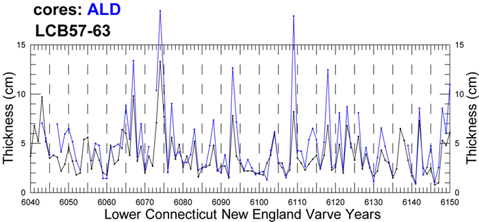
Correlation of the ALD record (blue) with LC 6043-6150 of the LC varves in the Connecticut Valley (black; Antevs, 1922). Breaks in the ALD record represent intervals disturbed by mass movement. The near perfect match on this plot is expected because Antevs compiled his LC chronology from outcrops close to the ALD site (see sites 32-37 on location map above).
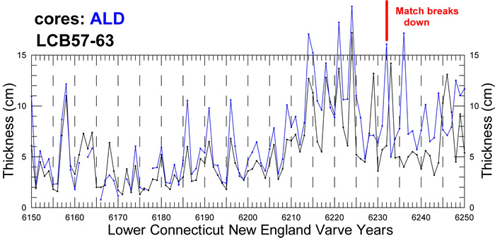
Correlation of the ALD record (blue) with LC 6150-6250 of the LC varves in the Connecticut Valley (black; Antevs, 1922). The relatively thin varves prior to LC 6205 represent a time when end moraine building and small readvances were occurring near Charlestown, NH. The sudden change to thick varves after LC 6205 represents the beginning of rapid ice recession (280 m/varve yr) that continued into the northern Connecticut Valley for about 5 centuries. (See NEVC Deglaciation) Note that after LC 6231 the match between the ALD record and the LC varves breaks down. A match of the two sequences will again briefly occur at LC 6250-6268 (see figure below). The breakdown of the match after the two records show a nearly perfect correspondence is due to the fact that above LC 6231 Antevs� LC sequence was formulated from sections where varves were very sandy as a result of prodeltaic or shallow water deposition and do not carry a regional glacial meltwater signal.
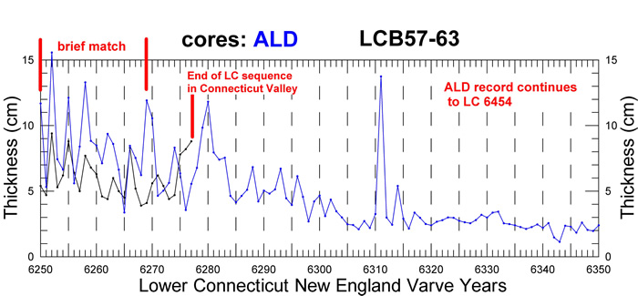
Correlation of the ALD record (blue) with LC 6250-6277 of the LC varves in Connecticut Valley (black; Antevs, 1922). A match of the two records occurs briefly at LC 6250-6268.
ALD Record vs. LC Varves of Merrimack Valley (Antevs, 1922)
A similar situation as above occurs when comparing the ALD record with Antevs� (1922) LC sequence for the Merrimack Valley. Antevs (1922) matched and correlated the Merrimack Valley sequence with the LC varves shown above for the Connecticut Valley and thus extended LC varve years to LC 6352. There is a near perfect match of the ALD record and the Merrimack Valley sequence from LC 6043-6231. Above LC 6231 to the top of the Merrimack sequence (LC 6352) there is no clear match with the ALD record. There is also no match between the LC varves of the Connecticut and Merrimack valleys above LC 6231. Above LC 6231 the Merrimack sequence is composed of very sandy shallow water and prodeltaic varves that apparently do not carry a regional glacial meltwater signal.
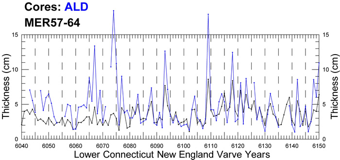
Correlation of the ALD record and Antevs� (1922) Merrimack Valley sequence for LC 6040-6150. Gaps in the ALD record are due to interruptions by mass movement. This high quality match is expected because Antevs� LC sequences for the Connecticut and Merrimack valleys match extremely well in this interval.

Correlation of the ALD record and Antevs� (1922) Merrimack Valley sequence for LC 6040-6150. Gaps in the ALD record are due to interruptions by mass movement. This high quality match is expected because Antevs� LC sequences for the Connecticut and Merrimack valleys match extremely well in this interval.
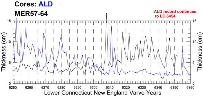
Correlation of the ALD record and Antevs� (1922) Merrimack Valley sequence from LC 6250-6360 (LC 6352 is the top of the Merrimack Valley sequence). There are only occasional, possibly random matches during this interval. The Merrimack sequence is composed of sandy prodeltaic or shallow water varves and does not carry a regional glacial meltwater signal. The ALD record appears to carry a regional signal as is explained with its match to the Perry Hill Basin record below.
Aldrich Brook (ALD) vs. Perry Hill (PH) Basin Cores (PHN, PHS)
Shown below is the match of the ALD and PH core records. The bottom 6 years of the PH records do not match the ALD record because they are extremely ice-proximal varves influenced by highly localized deposition along a receding ice front. These varves have thick sand beds with occasional ripples, slump deposits, and diamicton layers that reflect ice-proximal deposition. The ALD and PH records show a clear match beginning at about PH 7 or LC 6243. This match continues for over 200 years to PH 210 or LC 6446. The upper 9 years (LC 6447-6454) of the Aldrich Brook record (not shown here) do not show a match where they have been disturbed by core collection and weathering beneath a sand and gravel deposit. The match of the ALD and PH records is critical because it involves varve records from greatly different environments that are ~35 km apart. The PH records are from an ice-proximal environment while the ALD record is a very ice-distal record and has much thinner varves. The clear match of these two records is evidence that they are both depicting regional trends in varve thickness and are not reflecting localized patterns of deposition.
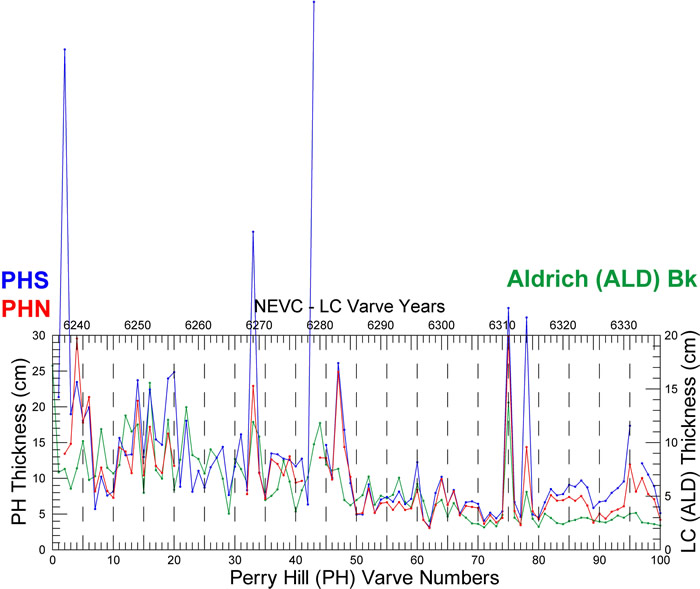
Correlation of ALD (green) and PH (red = PHN, blue = PHS) varve records from PH 0-100 and LC 6236-6336. A match between the PHN/PHS and ALD records begins to appear about 7 years above the base of the PH sequences (PH 7 or LC 6243). A very strong correlation develops at about PH 45 (LC 6281).
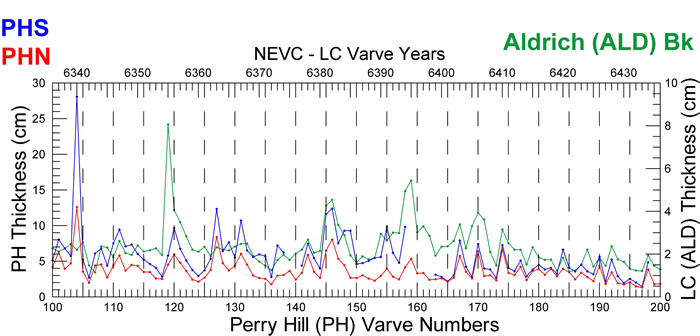
Correlation of ALD (green) and PH (red = PHN, blue = PHS) varve records from PH 100-200 or LC 6336-6446. The records show a very good match, which is the basis for the correlation.
Connections to the UC Varves
When aligned such that LC 6269 = UC 6601 = PH 32, there is a match of the ALD, PH, and very thick basal varves of the UC varves (Antevs (1922). The match of these sequences is very good even though the UC sequence, especially from UC 6601-6635, has a much greater absolute thickness (see different thickness scales on plot). This match continues to about UC 6674 where an apparent 1-yr offset begins with Antevs� UC varves appearing to have one less couplet at this point. This offset may be the result of a mistake in Antevs compilation of the UC varves. His varve identifications were made in the field and the recognition of winter layers can be difficult in moist exposures, especially if they are abnormally thin. All measurements made on the ALD and PH cores were from high resolution digital images of partially dried cores in which subtle grain size differences could be discerned more easily. When the PH record was compiled there was a varve in the PH sequence (PH 106 or LC 6342 = UC 6674) that has a very thin winter layer that could have easily been missed in the field (see image below). The 1-yr offset beginning at UC 6674 continues until UC 6744, which is a very thin and possibly extra varve in Antevs� sequence. In the PH (PH 177) and ALD (LC 6412) cores this varve has a silty clay bed in its summer layer that might easily be mistaken for a true winter layer on a moist outcrop. This may be the reason that Antevs� record has an extra varve at this position. Above UC 6744 the sequences are again in very close agreement until near the very top of the ALD record where varves are weathered, slightly deformed, and compressed beneath an unconformity overlain by pebbly sand in the ALD cores (see discussion of ALD vs. PH records above).
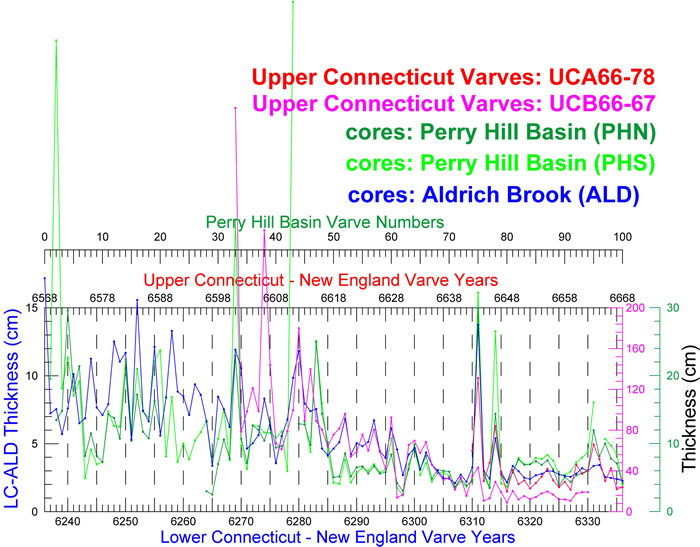
Correlation of varve records from the ALD (blue) and PH (green) cores, and the UC varves (red, magenta; Antevs, 1922) with PH 0-100 = LC 6236-6336 = UC 6568-6668. Note the huge difference in absolute thicknesses of the UC varves (especially in UC 6601-6635) vs. other varve records and yet the close match of the sequences.
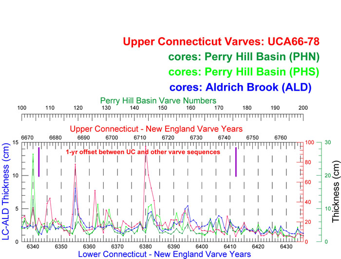
Correlation of the varve records from ALD (blue) and PH cores (green) and the UC varves (red) with PH 100-200 = LC 6336-6436 = UC 6668-6768. UC varves have much greater absolute thicknesses and have been plotted on the thickness scale (red) to the right. The area of the 1-yr offset between the UC varves and the other sequences has been labeled.
Potential source of error in the UC varve sequence as measured by Antevs (1922)
The images below show varves in the PH and ALD records at PH 104-108 and LC 6339-6344, the area of an apparent offset with the UC varves at UC 6674 where the UC sequence appears to be missing a varve. Antevs may have counted two varves (PH106-107, LC 6342-6343) as one where equivalent varves in the PH and ALD records have abnormally thin winter layers. Varve numbers on the images refer to the PH and LC numbering systems, red S = summer layer, blue W = winter layer, red line = base of summer layer, blue line = base of winter layer. Scales are in centimeters.
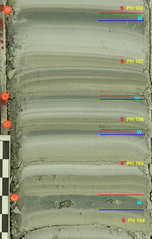
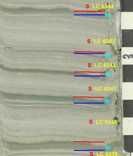
Left: Varves PH 106-107 in the Perry Hill Basin record at the beginning of the offset with the UC varves at UC 6674 (see plot above). Varves PH 105 and 106, but especially PH 106, have abnormally thin winter layers for this part of the PH sequence and could easily be overlooked if measured in the field on a moist outcrop. Antevs’ UC 6674 appears to be two varves measured as PH 106-107 in the PH record. Note that the bottom of each summer layer tends to be an olive gray muddy silt with fine sand while the upper parts of summer layers are a pure gray color and coarser. This is a pattern seen throughout the PH varve sequence and helps delineate annual layers. Right: Varves LC 6342-6343 in the Aldrich Brook record at the beginning of the offset with the UC varves at UC 6674 (see plot above). Varve PH 6342 has an abnormally thin winter layer for this part of the ALD sequence and could easily be overlooked if measured in the field on a moist outcrop. Antevs� UC 6674 may actually be two varves measured as LC 6342-6343 in the ALD record.
The images below show varves in the PH and ALD records at PH 177 and LC 6412, the point of an apparent offset with the UC varves at UC 6744 where the UC sequence appears to have an extra varve. Antevs may have counted one varve as two where equivalent varves in the PH and ALD records have an abnormally fine-grained bed in their summer layers. Note the general intra-annual correspondence of laminations that make up the equivalent summer layers of PH 177 and LC 6412. (Note that on the plots above the UC record is already shifted down or to the right by one year because of the offset discussed above at UC 6674.) Varve numbers on the images refer to the PH and LC numbering systems, red S = summer layer, blue W = winter layer, red line = base of summer layer, blue line = base of winter layer. Scales are in centimeters.
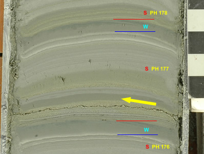
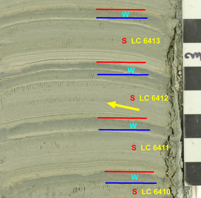
Left: Varve PH 177 in the Perry Hill Basin record at the end of the offset with the UC varves at UC 6744 (see plot above). Varve PH 177 has an abnormally clayey bed in its summer layer for this part of the PH sequence that might easily be counted as a separate winter layer if measured in the field on a moist outcrop. Antevs may have counted two varves, UC 6744-6745, that are actually one varve (PH 177) on this image from the PH record. Right: Varve LC 6412 in the Aldrich Brook record at the end of the offset with the UC varves at UC 6744 (see plot above). Varve LC 6412 has a subtle and faint, very thin, abnormally clayey bed in its summer layer. This layer was not mistaken as a winter layer in this part of the ALD sequence, which is composed of somewhat sandy ice-distal varves, because it is too thin and has some silt in it. Further up valley, as indicated in the image of PH 177, this mid-summer clayey bed is more prominent. Antevs may have counted two varves, UC 6744-6745, that are one varve (LC 6412) on this image from the ALD record.
Claremont Gap Closeure: LC and UC Correlation
The matching of the ALD and PH records to Antevs� (1922) LC and UC sequences establishes the time relationship between LC and UC varves of the NEVC and eliminates the Claremont Gap. The match of the sequences gives the following correspondence between the two NEVC numbering systems:
LC 6268 = UC 6600 or LC 6300 = UC 6632
or mathematically: LC varve year = UC varve year � 332
Antevs would not have known that his LC and UC sequences overlapped by 10 years in the Connecticut Valley, and by 85 years in the Merrimack Valley, because of the poor quality of the tops of both the Connecticut and Merrimack valley LC records for regional correlation. The original Claremont Gap as arbitrarily assigned by Antevs (1922; his NE 6278-6600 in the Connecticut Valley and NE 6353-6600 in the Merrimack Valley) was 332 years too long in the Connecticut Valley and 257 years too long in the Merrimack Valley. Nonetheless the Claremont Gap area was still a region of slow ice recession with an apparent 200-yr delay in continuous deglaciation represented by end moraine building and small readvances in the Charlestown area. See the plot of the Southern NH/VT deglaciation profile. Establishing the length of the delay in this interval places tight constraints on the ages of the end moraines and small readvances at Charlestown and allows a more accurate comparison with records of climate change such as from Greenland ice core records.
The discovery of the true correspondence of the LC and UC varve sequences has allowed a comprehensive calibration of the entire NEVC without having to separately calibrate its two major sequences. For the updated calibration go the NEVC Calibration page.
References
- Antevs, E., 1922, The recession of the last ice sheet in New England: American Geographical Society Research Series, no. 11, 120 p.
- Beck, C.C., 2008, Chronology and depositional characteristics of varves at Westmoreland, NH in the Connecticut Valley, U.S.A.: Unpublished Sr. Thesis, Dept. of Geology, Tufts University, Medford, MA, 72 p.
- Ridge, J.C., 2001, Surficial geologic map of part of the Springfield Quadrangle (7.5 x 15-minutes, 1:24,000), Sullivan County, N.H. and Windsor County, Vt.: New Hampshire State Geological Survey Open-file Report, 3 map sheets.
- Ridge, J.C., 2003, Chapter 3: The last deglaciation of the northeastern United States: a combined varve, paleomagnetic, and calibrated 14C chronology, in Cremeens, D.L. and Hart, J.P., eds., Geoarchaeology of Landscapes in the Glaciated Northeast: New York State Museum Bulletin 497, p. 15-45.
- Ridge, J.C., 2004, The Quaternary glaciation of western New England with correlations to surrounding areas, in Ehlers, J. & Gibbard, P.L. (eds.), Quaternary Glaciations � Extent and Chronology, Part II: North America. Developments in Quaternary Science, vol. 2b, Amsterdam, Elsevier, p. 163-193.
- Ridge, J.C., Thompson, W.B., Brochu, M., Brown, S., Fowler, B., 1996, Glacial geology of the upper Connecticut Valley in the vicinity of the lower Ammonoosuc and Passumpsic Valleys of New Hampshire and Vermont, in Van Baalen, M.R. (Ed.), Guidebook to Field Trips in Northern New Hampshire and Adjacent Regions of Maine and Vermont: 88th Annual Meeting, New England Intercollegiate Geological Conference, Harvard University, Cambridge, Massachusetts, pp. 309-340.
- Ridge, J.C., Besonen, M.R., Brochu, M., Brown, S.L., Callahan, J.W., Cook, G.J., Nicholson, R.S., and Toll, N.J., 1999, Varve, paleomagnetic, and 14C chronologies for late Pleistocene events in New Hampshire and Vermont, U.S.A.: G�ographie physique et Quaternaire, v.53, 79-108.
- Ridge, J.C., Canwell, B.A., Kelly, M.A., and Kelley, S.Z., 2001, An atmospheric 14C chronology for late Wisconsinan deglaciation and sea level change in eastern New England using varve and paleomagnetic records: in Weddle, T. and Retelle, M., Deglacial History and Relative Sea-level Changes, Northern New England and Adjacent Canada: Geological Society of America Special Paper no. 351, p. 171-189.
- Voytek, E., 2008, Measurement and analysis of a varve sequence in Perry hill Basin, Charlestown, NH: unpublished Sr. Thesis, Dept. of Geology, Tufts University, Medford, MA, 71 p.


