
Finding Varve Sections
Finding varve sections to study can be expedited in several ways. Old geologic papers and documents sometimes show varved silt and clay units or the locations of individual outcrops. Unfortunately, old publications will frequently describe exposures that no longer exist or development may eliminate areas with potential varve exposures at the land surface. Old brickyards, railroad or road cuts, and stream cuts will usually no longer have exposures but these areas are often places where slope failure can create new exposures.
The geomorphology of stream valleys is sometimes helpful in identifying areas with varve stratigraphy. Stream valleys underlain by clay and silt varves often display a meandering pattern as they traverse fine-grained varve deposits.
Detailed surficial mapping in the area of an ancient glacial lake is one way to find even the smallest exposures. Although this technique can be time consuming it may reveal the details of stratigraphic and geomorphic relationships that can aid in identifying preserved ancient lake floor surfaces and potential areas for drilling subsurface varve sections. Combining surficial map data with existing well/drill hole records is a powerful tool for locating future drill sites for varve study.
New England Examples
Locating Sites of Antevs
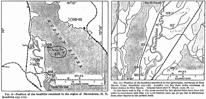
Location maps from Antevs (1928). Left: Haverstraw, New York. Right: Quinnipiac Valley near New Haven, Connecticut.
Using Geomorphology and Topography
Varve-floored valleys are often associated with meandering streams traversing the fine-grained varved sediment.
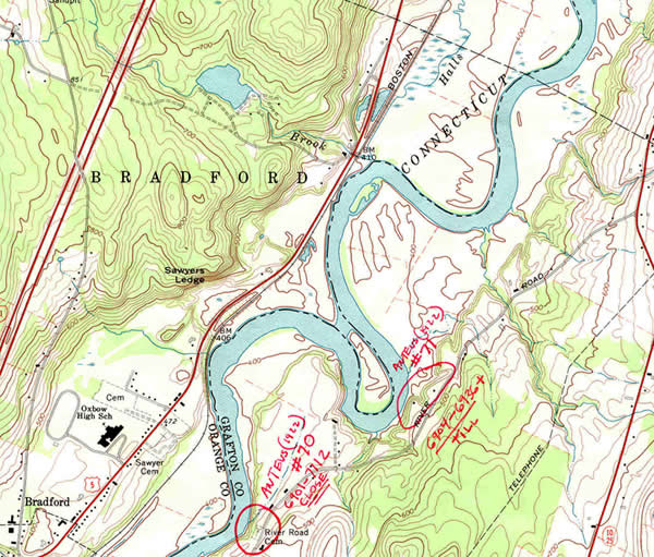
Upper Connecticut Valley, Bradford, VT.
Using Detailed Mapping Studies
Basins with preserved lake floor surfaces have complete sections that can be studied in core samples. Shown here are two examples, one from north of Bellows Falls, VT and the other from the Perry Hill Basin, Charlestown, NH. The blue unit on the surficial maps is lake floor clay and silt. Note that these deposits usually are fluvially dissected and capped by sandy stream terraces in the Connecticut Valley. North of Bellows Falls varved silt and clay was capped by lacustrine sand as the lake filled with sediment and became shallower. The Perry Hill basin was protected from erosion by being separated from the main Connecticut Valley by Calavant Mountain. It was also not covered by sand as the lake appears to have drained before it became shallow enough for lacustrine sand to be the primary lake floor sediment at the site.
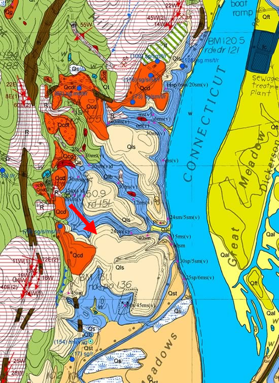
Surficial geologic map of the Bellows Falls, VT-NH 7.5 x 15-minute Quadrangle (Ridge, 1999, revised 2007). Large red arrow points to preserved lake floor with lacustrine sand overlying varved fine sand, silt and clay (blue).
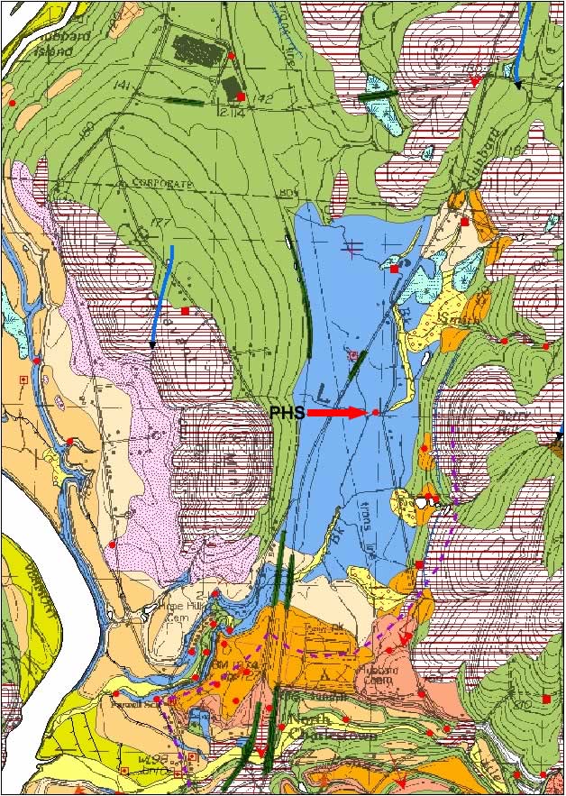
Surficial map (Ridge, 2001) showing location of Perry Hill South (PHS) drill site, Charlestown, NH.
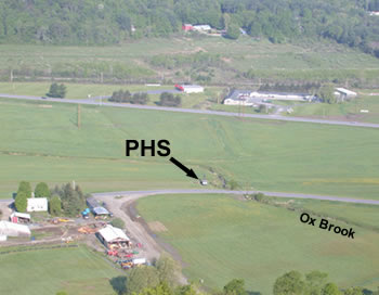
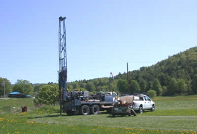
Left: View west from top of Perry Hill. Right: Drilling in Perry Hill basin at PHS May, 2007.
Getting Lucky
Occasionally artificial excavations for sand and gravel will expose varve sections. This is somewhat unusual because sand and gravel companies are usually trying to avoid silt and clay deposits unless they have a specific market for this material. At one place in Vermont, Canoe Brook, there was an excavation in varves for material to construct clay tennis courts. Other artificial excavations such as temporary road cuts or for foundations may reveal varves but these sites are usually open only briefly. It pays to know people in areas of known varve stratigraphy who can alert you to short-lived exposures.
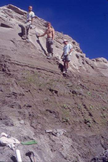
Longmoore Sand and Gravel Co., Site WR1, Wells River, Vermont in 2000. At this exposure an esker buried by a varve section was excavated for sand and gravel aggregate. The varved clay, silt, and sand at this exposure grades upward into non-varved lacustrine sand. (left to right: Brant Wilson, Britton Windler, and Glenn Cook)
References
- Antevs, E., 1922, The Recession of the Last Ice Sheet in New England: American Geographical Society Research Series, no. 11, 120 p.
- Antevs, E., 1928, The Last Glaciation with Special Reference to the Ice Sheet in North America: American Geographical Society Research Series, no. 17, 292 p.
- Ridge, J.C., 1999, Surficial Geologic Map of the Bellows Falls Quadrangle (7.5 x 15-minutes), Cheshire and Sullivan Counties, N.H. and Windham and Windsor Counties, Vt.: New Hampshire State Geological Survey Open-file Report, 2 map sheets.
- Ridge, J.C., 2001, Surficial Geologic Map of part of the Springfield Quadrangle (7.5 x 15-minutes), Sullivan County, N.H. and Windsor County, Vt.: New Hampshire State Geological Survey Open-file Report, 3 map sheets.