
Varves of the Month for 11/1/2009 - 11/30/2009
Connecticut Valley Varves, Perry Hill Basin, Charlestown, New Hampshire.
Scale bar in cm.
Click on image to download original image file
Since February 2009 and continuing until January 2010 is a series of images that show the progressive change in varve deposition that occurred over time in the Perry Hill Basin. The Perry Hill Basin core sites, PHS and PHN which is 0.5 km further north, are in the same varve-filled basin at the west flank of Perry Hill in Charlestown, NH just south of Claremont and have very similar varve stratigraphy. The complete section contains over 500 varves from ice-proximal varves at the base that rest on till to very ice-distal varves at the top of the section that fade into sediment in which varves are difficult to discern because winter layers are erratically preserved. In the following months we will show varves that get progressively younger and more ice-distal as ice receded further and further north from the Perry Hill Basin. Varves-of-the-Month for September and October 2008 were also from Perry Hill Basin cores (see the archive at the bottom of this page). The general type and relative ages of the varves in the New England Varve Chronology (NEVC) in past Varves-of-the-Month images from the Perry Hill Basin are indicated on the varve plot and below with the oldest varves at the bottom of the list:
- November 2009 NE6985-6997 : (This month) Distal varves
- October 2009 NE6944-6953: Distal varves
- September 2009 NE6897-6905: Distal varves
- August 2009 NE6853-6864: Transitional varves
- July 2009 NE6804-6818: Transitional varves + flood event
- June 2009 NE6751-6768: Thinning transitional varves
- May 2009 NE6687-6691: Thick transitional varves
- April 2009 NE6652-6655: Return to ice-proximal varves
- September 2008 NE6640-6644: Ice-proximal/transitional varves + flood event
- March 2009 NE6631-6635: Return to ice-proximal varves
- October 2008 NE6622-6625: Ice-proximal to transitional varves
- February 2009 NE6590-6593: Thick, ice-proximal varves
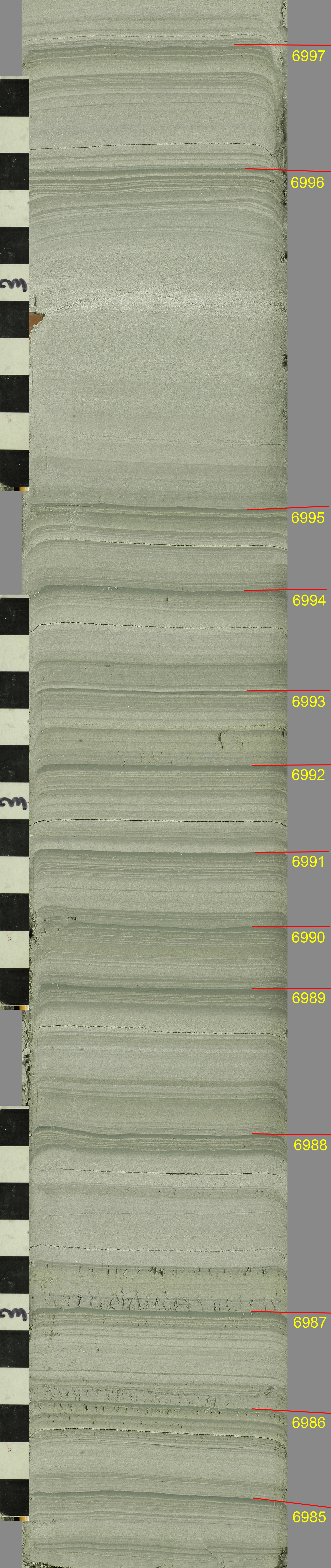
This month's varves are on four successive core images that have been stitched together. The images were chosen because of the summer layer detail that they show and the "flood" event near the top of the image. This is a distal sequence from glacial Lake Hitchcock in the Perry Hill Basin (PHS core) of the Connecticut Valley of south-central New Hampshire. The sample was collected in the summer of 2007 with a Central Mining Equipment continuous sampling system running inside a hollow-stem auger at a depth of 20.0-18.7 feet. The top of this interval is 83.8 ft and 429 varves above the bottom of the varve section at the PHS core site where varves rest on till. Red lines on the image define boundaries between each annual layer (bottom of summer or melt season layer resting on top of the preceding winter or non-melt season layer). Lines are not used to show the separation of the summer silt and winter clay layers within each varve as in past months because this boundary is difficult to define (see below). he numbers adjacent to the winter layer of each varve are years in the upper Connecticut varves of the New England Varve Chronology (NEVC) of Ernst Antevs (1922). A plot of the Perry Hill varves vs. Antevs' upper Connecticut varve record is shown below. After a sporadic match, following the major flood event at ~NE6810, the Perry Hill and NEVC records again match well above ~NE6905 through the varves shown this month. The varve sequence in the Perry Hill Basin was critical to closing a gap in the NEVC between Antevs' lower and upper Connecticut varve sequences. For more on closure of the Claremont Gap go to:Closure of the Claremont Gap.
This month's varves are mostly moderately thick (1.6-4.0 cm) distal varves with two varves of abnormal thickness (4.8 and 9.2 cm) that probably represent flood events. In terms of a definition, ice-proximal varves are composed of sediment almost entirely derived directly from glacial runoff and the summer layer is easily split into three units representing the early, main, and late melt seasons. Ice-distal varves have a large contribution of sediment from tributary drainages that is remobilized by lake bottom currents and varves with clear melt season subdivisions are rare. The change to distal varves up section is a natural consequence of ice recession. In this month's varves both the early and late melt season layers are absent. The varves were deposited 418-429 years after recession of the ice sheet when the ice-front had receded approximately 120 kilometers north of the PHS core site to near the mouth of the Passumpsic River Valley in Vermont and to near Lisbon, NH. The ice recession rate in the Connecticut Valley at this time averaged approximately 280 m/yr, which is very rapid for a terrestrial glacier where most of the ablation is by melting.
The summer or melt season layers (lower parts of each varve) are composed of a complex stack of graded fine sand to muddy silt beds. The summer layers are slightly sandier and thicker than in normal distal varves. Unlike in areas to the south the distal varves of the Perry Hill core sites are thicker than transitional varves lower in the section (see June and July 2009 Varves-of-the-Month). For example, distal varves near Hartford, Connecticut (see Varves-of-the-Month for 4/27/2008) are much thinner and more clayey with winter layers as thick or thicker than summer layers. The upper Connecticut Valley had more rapid ice recession and annual meltwater production was higher. The upper Connecticut basin also has higher relief, which promotes paraglacial erosion following deglaciation, and in the Perry Hill area the valley is narrow, which forces sediment accumulation in a confined area rather than spreading it over a wider basin. The stacked graded summer units represent melting or storm events. Many of the graded units that contain fine sand appear to be derived from sediment delivered to the lake by tributaries and then remobilized by bottom currents. Correlative ice-proximal varves further north in the Connecticut Valley are less sandy than the distal varves shown here. Sand became more prevalent at the Perry Hill sites as prograding deltas delivered more sandy sediment further into the lake basin where it was picked up by strong down valley currents. A major source of sand is the Sugar River Valley just to the north at Claremont. Very thin rhythmic, possibly diurnal, units are apparent near the top of almost every summer layer in this image and impinge on the winter clay layer. Ice-rafted medium to coarse sand grains apparent in the images of the last two months are absent from this part of the Perry Hill section.
The winter or non-melt season layers are dark bluish- to greenish-gray clay beds where NEVC numbers are posted on the image. Some of the winter beds have a very dark color on their upper surface that may be related to fine organic accumulation. All of the winter clay beds on this image are thin (a few millimeters) and have very subtle normal grading from silty clay at the bottom to nearly pure clay at the top. In most cases the clay layers are hard to evaluate as winter layers because it appears that initial clay deposition is interrupted by sand and silt laminations, creating a split clay layer, which becomes more common in distal varves. Clay deposition appears to begin in some years prior to the end of runoff and melting events, making the clay bed a combined late summer and winter layer. The splitting of clay layers negates a meaningful correlation between winter and summer layer thickness.
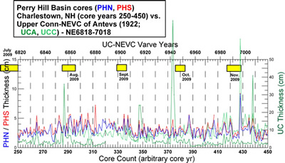
A match of the Perry Hill Basin cores (PHN, PHS) vs. the upper Connecticut (UC) varves of a corrected NEVC (data files are available in Downloads). Note the different thickness scales of the varve records: PH on left, UC on right. Gaps in the PH records due to incomplete core recovery are interpreted through matching of the PH cores to each other, the NEVC, and other core records. The yellow boxes show the positions of this month's and previous Varves-of-the-Month from the Perry Hill Basin.
One very thick varve in this month's image (NE6996) appears to represent a flood event. The flood shown this month also appears as a prominent event on an NEVC record measured by Ernst Antevs (1922) just north of Claremont and near Hanover. Antevs interpreted the flood event as coming from north of Hanover although it does not appear on the NEVC record measured in the northern Connecticut Valley near Wells River, VT and Woodsville, NH. This suggests that the event may be related to a flood out of the White River basin or another local source and not related to the release of glacial lake water in the northern Connecticut Valley at the margin of the receding glacier. In the Perry Hill section the flood event is represented by a thick very faintly bedded layer that appears to be initially inversely graded from muddy silt to fine sand and then above this normally graded back to muddy silt. This is unusual in that flood events, especially when catastrophic and from the release of water from a glacial lake, are usually large normally graded units (see Sept. 2008 and July 2009). The bedding arrangement suggests that a flooding current entering the Perry Hill basin was initially weak, grew in strength, and then waned.
Past Varves of the Month...
- 6/1/2008 - Connecticut Valley Varves at Canoe Brook, Dummerston, Vermont
- 4/27/2008 - Connecticut Valley Varves from Kelsey Ferguson Brickyard, Redland Brick Co., East Windsor, Connecticut.
- 7/1/2008 - Champlain Valley varves at Keesville, NY
- 8/1/2008 - Connecticut Valley Varves at Aldrich Brook, Westmoreland, New Hampshire
- 9/1/2008 - Connecticut Valley Varves, Perry Hill Basin (PHS), Charlestown, New Hampshire
- 10/1/2008 - Connecticut Valley Varves, Perry Hill Basin (PHN), Charlestown, New Hampshire.
- 11/1/2008 - Connecticut Valley Varves, Aldrich Brook site, Westmoreland, New Hampshire
- 12/1/2008 - Connecticut Valley Varves, Aldrich Brook site, Westmoreland, New Hampshire
- 1/1/2009 - Mine fire reclamation site, Olyphant, Pennsylvania
- 2/1/2009 - Connecticut Valley Varves, Perry Hill Basin (PHS), Charlestown, New Hampshire
- 3/1/2009 - Connecticut Valley Varves, Perry Hill Basin, Charlestown, New Hampshire
- 4/1/2009 - Connecticut Valley Varves, Perry Hill Basin, Charlestown, New Hampshire.
- 5/1/2009 - Connecticut Valley Varves, Perry Hill Basin, Charlestown, New Hampshire
- 6/1/2009 - Connecticut Valley Varves, Perry Hill Basin, Charlestown, New Hampshire
- 7/1/2009 - Connecticut Valley Varves, Perry Hill Basin, Charlestown, New Hampshire
- 8/1/2009 - Connecticut Valley Varves, Perry Hill Basin, Charlestown, New Hampshire
- 9/1/2009 - Connecticut Valley Varves, Perry Hill Basin, Charlestown, New Hampshire
- 10/1/2009 - Connecticut Valley Varves, Perry Hill Basin, Charlestown, New Hampshire
- 12/1/2009 - Connecticut Valley Varves, Perry Hill Basin, Charlestown, New Hampshire
- 1/1/2010 - Connecticut Valley Varves, Perry Hill Basin, Charlestown, New Hampshire
- 2/1/2010 - Varves along Starrucca Creek near Lanesboro, Pennsylvania
- 3/1/2010 - Varves in the Don Valley, Toronto
- 4/1/2010 - Varves along Sandy Stream, Dennistown Plantation near Jackman, Maine
- 5/3/2010 - Varves from Glacial Lake Great Falls in Montana
- 6/4/2010 - Varves from Charlestown, NH
- 7/1/2010 - Varves from Redlands Brick Co. (Kelsey Ferguson Brickyard, South Windsor, Connecticut) - A varve that Antevs missed
- 8/1/2010 - Varves from Glastonbury, Connecticut
- 9/1/2010 - Varves from North Hatfield, Massachusetts
- 10/1/2010 - Varves from Newbury, Vermont
- 11/1/2010 - Varves from Newbury, Vermont
- 12/1/2010 - Varves from Newbury, Vermont
- 2/1/2011 - Connecticut Valley Varves at North Hatfield, Massachusetts
- 3/1/2011 - Connecticut Valley Varves Kelsey Ferguson (Redlands Brick Co.), South Windsor, Connecticut
- 6/1/2011 - Connecticut Valley Varves: Core at Scantic, East Windsor, Connecticut
- 8/1/2011 - Varves of West Canada Creek Valley, western Mohawk Valley
- 10/1/2011 - Varves of West Canada Creek Valley, western Mohawk Valley collected in Newport, NY
- 12/1/2011 - Connecticut Valley Varves at Claremont Junction, NH
- 3/1/2012 - Connecticut Valley Varves at Westmoreland, NH
- 7/1/2012 - Connecticut Valley Varves at Rt. 12A drill site in North Charlestown, N.H.