
Varves of the Month for 10/1/2010 - 10/31/2010
Varves from Newbury, Vermont
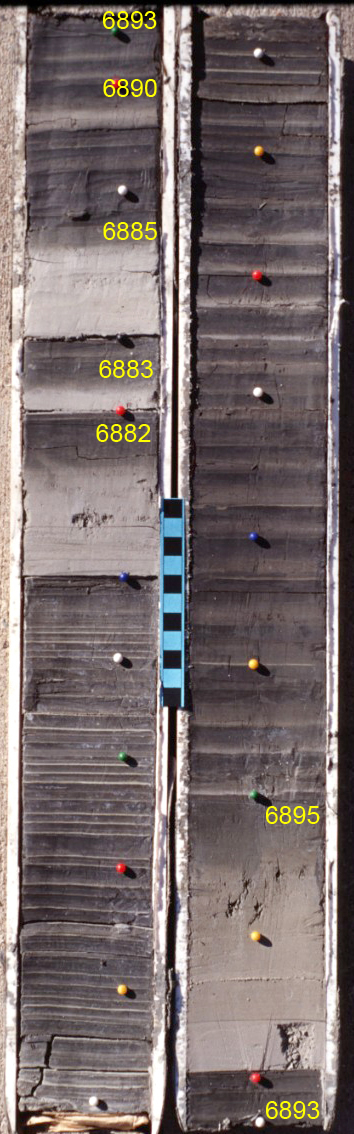
Scale bar in cm.
Click on image to download original image file
This month's varves are gray varves from outcrop cores at Newbury, Vermont. The varves were collected in 1996 and the successive split cores were partially dried to make the summer and winter layers more easily discernable. The varves on this image have been matched to the North American Varve Chronology (NAVC or AM years). A plot of the varve record from this site (NEWBswT) is matched to a record of Antevs (1922; UCA63-75) and outcrop cores from the Passumpsic Valley (PAS2TOT), both translated to AM years. The varves on the image were deposited ~14,100 yr ago and ~35 km south of the receding ice front during the time of the Littleton Readvance (see ice margin on map).
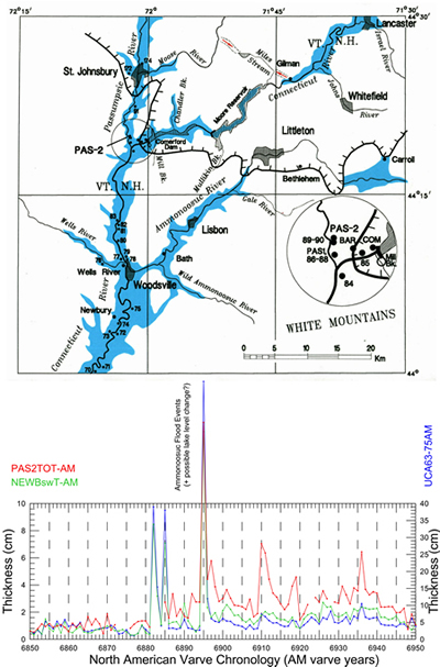
Above: Map of the upper Connecticut Valley showing the Newbury varve site (site 73) and glacial lakes formed during deglaciation. Flood events seen in the Connecticut Valley varves are the result of the release of water from an ice-marginal lake at Carroll, NH into the Gale River and Ammonoosuc Valley. The ice margin on the map depicts the limit of the Littleton Readvance. Below: Plot of the NAVC varve years AM 6850-6950 showing the thickening of varves associated with the Ammonoosuc flood events. Shown matched to the Newbury record (green) are Antevs (1922) original "normal curve" for the upper Connecticut Valley (blue, UCA63-75) and a record from outcrop cores in the Passumpsic Valley (PAS2TOT).
The NAVC in the Connecticut Valley shows abrupt changes in varve thickness that are maintained for at least a few decades. These positions in the varve chronology may represent times of lake level change or if varve thickness is not maintained for very long they may represent flood events into the Connecticut Valley from the release of water in tributary lakes. In the upper Connecticut Valley ice recession occurred while a low stable stage of Lake Hitchcock occupied the valley that has informally been called the Cold River Stage. This level of Lake Hitchcock is represented by deltas from northern Massachusetts to northern Vermont and New Hampshire. Lake water persisted in the valley after the drainage of the Cold River Stage and sediment from these lower unnamed lake stages has been cored at Newbury, VT and North Haverill and Hanover, NH. At this point not much is known about the spillways and chronology of these postglacial sub-Cold River lake stages and no names have been given to them.
The varve record from Newbury, as well as the other varve records, show a prominent and abrupt change to thicker varves that represents flood events created by the release of water from the upper Ammonoosuc Valley near Carroll, NH by way of the Gale River (see the map below). The flood varves (varves with flood events in them) are also associated with a permanent change in varve thickness that may represent a change in lake level, perhaps the transition from the Cold River Stage of Lake Hitchcock to lower lake levels. The two cores shown here overlap with the top varve on the left core matching the bottom varve on the right core. Prior to the flood events varves are very thin (bottom of left core). After the 3rd flood event in AM 6885 average varve thickness (excluding the flood varves) is ~3X thicker than before the flooding. Climate change to warming and more rapid glacial melting at ~AM 6925 may also have contributed to the permanent increase in varve thickness. This lake level transition would have taken place when the receding ice front was building an end moraine complex that stretches from Bethlehem, NH westward through Littleton to St. Johnsbury, Vermont, all associated with the Littleton Readvance (see map).
References
- Antevs, Ernst, 1922, The recession of the last ice sheet in New England: American Geographical Society Research Series, no. 11, 120 p. (with a preface and contributions by J.W. Goldthwait).
Past Varves of the Month...
- 6/1/2008 - Connecticut Valley Varves at Canoe Brook, Dummerston, Vermont
- 4/27/2008 - Connecticut Valley Varves from Kelsey Ferguson Brickyard, Redland Brick Co., East Windsor, Connecticut.
- 7/1/2008 - Champlain Valley varves at Keesville, NY
- 8/1/2008 - Connecticut Valley Varves at Aldrich Brook, Westmoreland, New Hampshire
- 9/1/2008 - Connecticut Valley Varves, Perry Hill Basin (PHS), Charlestown, New Hampshire
- 10/1/2008 - Connecticut Valley Varves, Perry Hill Basin (PHN), Charlestown, New Hampshire.
- 11/1/2008 - Connecticut Valley Varves, Aldrich Brook site, Westmoreland, New Hampshire
- 12/1/2008 - Connecticut Valley Varves, Aldrich Brook site, Westmoreland, New Hampshire
- 1/1/2009 - Mine fire reclamation site, Olyphant, Pennsylvania
- 2/1/2009 - Connecticut Valley Varves, Perry Hill Basin (PHS), Charlestown, New Hampshire
- 3/1/2009 - Connecticut Valley Varves, Perry Hill Basin, Charlestown, New Hampshire
- 4/1/2009 - Connecticut Valley Varves, Perry Hill Basin, Charlestown, New Hampshire.
- 5/1/2009 - Connecticut Valley Varves, Perry Hill Basin, Charlestown, New Hampshire
- 6/1/2009 - Connecticut Valley Varves, Perry Hill Basin, Charlestown, New Hampshire
- 7/1/2009 - Connecticut Valley Varves, Perry Hill Basin, Charlestown, New Hampshire
- 8/1/2009 - Connecticut Valley Varves, Perry Hill Basin, Charlestown, New Hampshire
- 9/1/2009 - Connecticut Valley Varves, Perry Hill Basin, Charlestown, New Hampshire
- 10/1/2009 - Connecticut Valley Varves, Perry Hill Basin, Charlestown, New Hampshire
- 11/1/2009 - Connecticut Valley Varves, Perry Hill Basin, Charlestown, New Hampshire.
- 12/1/2009 - Connecticut Valley Varves, Perry Hill Basin, Charlestown, New Hampshire
- 1/1/2010 - Connecticut Valley Varves, Perry Hill Basin, Charlestown, New Hampshire
- 2/1/2010 - Varves along Starrucca Creek near Lanesboro, Pennsylvania
- 3/1/2010 - Varves in the Don Valley, Toronto
- 4/1/2010 - Varves along Sandy Stream, Dennistown Plantation near Jackman, Maine
- 5/3/2010 - Varves from Glacial Lake Great Falls in Montana
- 6/4/2010 - Varves from Charlestown, NH
- 7/1/2010 - Varves from Redlands Brick Co. (Kelsey Ferguson Brickyard, South Windsor, Connecticut) - A varve that Antevs missed
- 8/1/2010 - Varves from Glastonbury, Connecticut
- 9/1/2010 - Varves from North Hatfield, Massachusetts
- 11/1/2010 - Varves from Newbury, Vermont
- 12/1/2010 - Varves from Newbury, Vermont
- 2/1/2011 - Connecticut Valley Varves at North Hatfield, Massachusetts
- 3/1/2011 - Connecticut Valley Varves Kelsey Ferguson (Redlands Brick Co.), South Windsor, Connecticut
- 6/1/2011 - Connecticut Valley Varves: Core at Scantic, East Windsor, Connecticut
- 8/1/2011 - Varves of West Canada Creek Valley, western Mohawk Valley
- 10/1/2011 - Varves of West Canada Creek Valley, western Mohawk Valley collected in Newport, NY
- 12/1/2011 - Connecticut Valley Varves at Claremont Junction, NH
- 3/1/2012 - Connecticut Valley Varves at Westmoreland, NH
- 7/1/2012 - Connecticut Valley Varves at Rt. 12A drill site in North Charlestown, N.H.